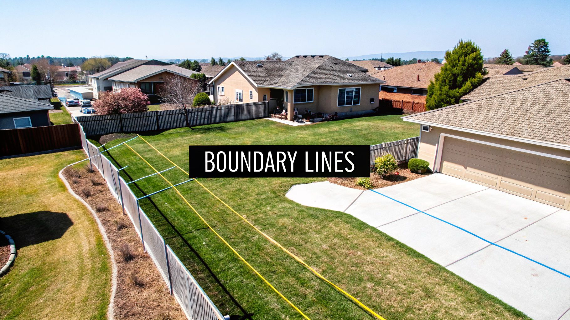
When you first glance at a property survey, it can look like a jumble of lines, symbols, and strange abbreviations. But once you know what you’re looking for, it all starts to make sense. The most important things to spot right away are the boundary lines (what you actually own), any easements (where others can use your land), and the improvements (all the structures currently on the property).

Think of the survey’s legend as your decoder ring. A quick look there will tell you what each symbol means, turning that complicated map into a straightforward guide for your Dallas property.
Your Guide to Understanding a Dallas Property Survey
Don’t mistake a property survey for just another map; it’s a critical legal document. It’s the official, definitive record of your property’s boundaries, the structures on it, and any limitations that come with it. This piece of paper is non-negotiable, whether you’re planning a new build in Bishop Arts or trying to settle a fence dispute with a neighbor in Lakewood.
For any Dallas-area property owner or real estate investor, knowing how to decipher a property survey is a genuinely powerful skill. It’s what protects your investment and unlocks the true potential of what you can do with your land. This guide will walk you through the key elements, so you can turn what seems like an intimidating document into a tool for making smart, confident decisions.
Why Surveys Are So Important in Dallas
A survey is the bedrock of good real estate due diligence. It brings clarity to the table and helps you sidestep expensive mistakes down the road. Without one, you’re basically just guessing about the true extent of what you own.
Here’s why a survey is absolutely essential in the Dallas market:
- Defining Your Legal Boundaries: It draws the exact lines of your property. This is your first line of defense against disputes with neighbors over where a fence, driveway, or even just some new landscaping can go.
- Spotting Encumbrances: A survey uncovers any easements or setbacks that restrict how you can use certain parts of your land. This is crucial information to have before you start planning that new pool, a home addition, or even a simple storage shed.
- Securing Financing and Insurance: Lenders and title companies here in Texas almost always require a current survey before they’ll issue a loan or a title policy. It confirms the property’s legal description and flags potential risks. To get the full picture, you also need to know how to read a title report, as it works hand-in-hand with your survey.
To get an even more complete grasp on property documents, especially how new developments are illustrated, Dallas property owners should also look into understanding site plans. This knowledge helps clarify how land use is officially recorded and planned out.
A survey is your best defense against future legal challenges. It provides a snapshot of your property at a specific moment in time, documenting everything from utility lines to the neighbor’s encroaching shed.
Being able to interpret these documents is only getting more important. The global land surveying market is projected to grow from USD 7.62 billion to USD 14.17 billion by 2035, and the technology behind them is getting more sophisticated every year. As Dallas continues its explosive growth—with urban development projects making up about 52% of all surveyed land use—understanding these maps has become a fundamental skill for any property owner.
To help you get started, here’s a quick reference table breaking down the most common elements you’ll find on a survey.
Key Elements on a Dallas Property Survey
| Element | What It Represents | Why It Matters in Dallas |
|---|---|---|
| Boundary Lines | The legal perimeter of your property, shown with bearings and distances. | Defines exactly what you own and prevents disputes with neighbors over fences or driveways. |
| Easements | Designated areas where utility companies or others have the right to access your land. | Can restrict where you build. A utility easement might prevent you from putting in a pool. |
| Improvements | All existing structures on the property, like the house, garage, shed, and fences. | Confirms that existing structures are within your property lines and not encroaching on a neighbor. |
| Setback Lines | Lines showing how far structures must be from property lines, per Dallas zoning codes. | Critical for planning any new construction or additions to ensure you’re in compliance. |
| Encroachments | When a neighbor’s structure (like a fence or shed) crosses over onto your property. | A potential legal issue that needs to be resolved before you close on the property. |
| Legal Description | The formal, official description of the property used in legal documents. | This is what the title company and lender use to identify the property; it must match perfectly. |
Keep this table handy as you review your document. It’s a great cheat sheet for decoding the language of surveyors and making sure you don’t miss any critical details.
Finding and Interpreting the Survey Legend
Think of a property survey as a map written in its own language. Your key to understanding it? The legend. This is the absolute first place you should look. It’s usually a small box tucked into a corner of the document, and it acts as your decoder ring, defining every symbol, line, and abbreviation the surveyor used.
Without getting comfortable with the legend first, you’re essentially just staring at a bunch of meaningless shapes. The legend is what turns that jumble of lines into a clear picture of your Dallas property, unlocking all the critical information held within the survey.
Decoding Common Dallas Survey Symbols
Once you’ve found the legend, you’ll start to see some common players. While a few symbols might differ from one surveyor to another, most professionals in Dallas stick to a standard set of conventions.
For example, a solid, heavy line is almost universally used to mark the property boundary—the official perimeter of your land. In contrast, you’ll often see dashed or dotted lines indicating features that exist within or cross over those boundaries.
You might spot a dashed line marked “U.E.,” which stands for a utility easement. This is a crucial detail, as it marks a strip of your land where companies like Oncor have the legal right to work on their equipment. You’ll also see little icons for physical structures like fences, gates, or even large, significant trees.
This infographic breaks down a simple, three-part way to approach your survey.
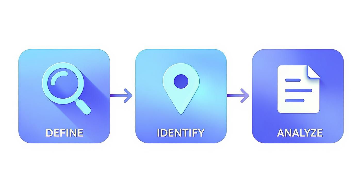
Following this visual flow keeps things simple: start with the legend to define the symbols, then find those key features on the map itself, and finally, think through what they actually mean for your property.
Distinguishing Key Lines and Boundaries
The legend is your best friend when it comes to telling apart the different types of lines on the survey. This isn’t just academic; misreading these lines can lead to some seriously expensive mistakes, especially with the strict zoning we have here in Dallas.
Pay close attention to these three critical lines:
- Property Line: This is the big one—the legal boundary of your land. Everything on your side of this line is yours.
- Setback Line: This line is dictated by City of Dallas zoning rules. It shows the minimum distance from your property line where a permanent structure can be built. Cross this line without permission, and you could be facing fines or even a demolition order.
- Easement Boundary: This outlines the specific area of an easement. It’s still your property, but your ability to use that portion of land is limited by the rights of the easement holder (like the utility company).
I see this all the time in historic Dallas neighborhoods like the M-Streets or Junius Heights, where setback lines are enforced with an iron fist to preserve the area’s unique look. A survey might show a 25-foot front setback. That means any new porch or home addition must be built behind that line, even if your actual property line is closer to the street. Knowing the difference is absolutely vital before you even think about hiring a contractor.
Analyzing Boundaries, Encroachments, and Improvements
Okay, this is where the rubber meets the road. All those abstract lines and symbols on the survey directly translate into your ownership rights—and potential headaches. This section helps you trace the legal perimeter of your property and spot any structures that might be crossing those all-important lines.
Getting a handle on this is critical, especially in dense Dallas neighborhoods where properties are practically on top of each other and every single inch counts. Catching a problem now can save you a world of hurt and costly legal battles down the line.
Tracing Your Property’s Legal Perimeter
Your survey defines the property boundaries using precise measurements called bearings and distances. These look like a string of surveyor’s code (something like N 89°15’30” E 150.00′), which pinpoints the exact direction and length of each property line. Don’t worry, you don’t need a math degree to understand it.
Just follow the solid lines that form the outer edge of the lot on the drawing. That visual outline is the exact, legally recognized shape and size of the land you’re buying. The first thing you should do is confirm that the house and other key structures are sitting comfortably inside this perimeter.
For some extra context, it can be helpful to dig into the property’s past. Learning how to research property history is a great complementary skill to have in your back pocket.
Identifying Improvements on the Property
In surveyor-speak, “improvements” are any permanent, man-made structures on the land. We’re not just talking about the main house. This includes everything:
- Detached garages and sheds
- Driveways and walkways
- Patios and decks
- Fences and retaining walls
The survey should map out all these features. As you look it over, mentally check off each item on the drawing against what you see when you walk the property. This double-check confirms that the survey is up-to-date and that all the structures are actually where they’re supposed to be.
Spotting Encroachments and Potential Disputes
An encroachment is what happens when something from a neighboring property crosses over your boundary line, or when one of your structures crosses onto their land. In tightly packed Dallas areas like Oak Cliff or Lower Greenville, these are way more common than you’d think.
A classic example is a neighbor’s new fence that was accidentally installed a foot over the property line. Or maybe a shared driveway where one owner builds a carport that partially blocks the other’s access.
I once worked on a deal involving a commercial lot next to a residential property in East Dallas. The survey revealed that a large retaining wall from the commercial site was encroaching by nearly two feet. Resolving this required legal agreements before the buyer could secure financing, highlighting why identifying these issues early is so critical.
Look very closely at where fences, sheds, and driveways meet the property line on your survey. Any structure that even appears to cross that line is a major red flag. It’s something you need to get a real estate attorney to look at immediately, well before you head to the closing table.
Cracking the Code on Easements and Setbacks in Dallas
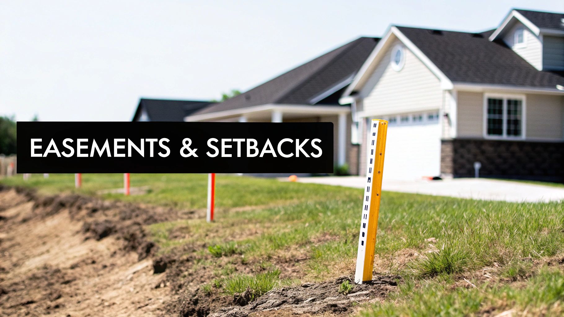
Alright, now that we’ve found the main property lines, let’s look at the other lines crisscrossing your survey. These are the ones that really dictate what you can and can’t do with your land. In a densely developed place like Dallas, understanding easements and setbacks isn’t just a good idea—it’s absolutely critical.
These restrictions will make or break your plans for a new pool, a garage expansion, or even just a simple fence.
What’s an Easement, Really?
Think of an easement as a legal right granted to someone else to use a specific slice of your property for a particular reason. You still own the dirt, but another party—often a utility company or the city—has a permanent key to that area.
These aren’t suggestions; they are legally binding restrictions that are attached to the property deed and pass from one owner to the next.
On your survey, you’ll spot easements marked by dashed or dotted lines, often with an abbreviation telling you what it’s for.
- Utility Easements (U.E.): This is the one you’ll see on nearly every Dallas property. It gives companies like Oncor Electric Delivery or Atmos Energy the right to run and maintain their lines. You absolutely cannot build any permanent structure—not a shed, not a deck, nothing—on top of a utility easement.
- Access Easements: Ever see a long driveway that crosses one yard to get to a house in the back? That’s an access easement. It’s common in older neighborhoods where lots were divided oddly, giving a landlocked neighbor the legal right to pass through.
- Drainage Easements (D.E.): Given the flash floods we can get in North Texas, these are a big deal. A D.E. keeps a natural water path clear. If you block one by building a wall or changing the grade, you could flood your neighbor and land yourself in serious legal trouble.
Here’s a good way to think about it: An easement is like a permanent guest room on your property that you can’t lock. The utility company has a key and can show up anytime to do their work. Trying to build a patio over their “room” will only end with them tearing it up, and you’ll be the one footing the bill.
The table below breaks down the most common easements you’ll encounter on a Dallas-area survey.
Common Dallas Easements and Their Impact
| Easement Type | Common Holder (in Dallas) | Impact on Property Use |
|---|---|---|
| Utility (U.E.) | Oncor Electric, Atmos Energy, City Water | Prohibits permanent structures (buildings, pools). Landscaping is usually okay, but they can dig it up for maintenance. |
| Drainage (D.E.) | City of Dallas, Homeowners Association | You cannot alter the land’s slope or build anything that impedes water flow. This is non-negotiable. |
| Access | Neighboring property owner | Guarantees passage for a neighbor. You cannot block this area with fences, vehicles, or structures. |
| Sanitary Sewer | City of Dallas | Similar to a utility easement but specifically for underground sewer lines. Construction is strictly forbidden over these lines. |
Understanding these is a foundational step in your due diligence, ensuring you don’t buy a property with restrictions that derail your future plans.
Understanding Setback Lines
So, while easements are about other people’s rights on your land, setback lines are all about the city’s rules for your structures. These are zoning regulations from the City of Dallas that define how far your house, garage, or any other building has to be from the front, side, and rear property lines.
The whole point is to ensure everyone has a bit of breathing room—proper airflow, light, and, crucially, access for emergency vehicles.
Surveyors typically draw setback lines as dotted or thin solid lines located inside your main boundary lines. A good survey will note if any part of your house or another structure crosses a setback line, creating what’s called an “encroachment.”
If an old home was built before the current rules, it might be “grandfathered in.” But any new additions you plan will have to follow today’s codes to the letter. This is exactly why a comprehensive real estate due diligence checklist is so important before you close.
The world of property surveying is constantly evolving, with the global market projected to jump from USD 10.3 billion in 2025 to over USD 15.3 billion by 2032, according to data on Metastat Insight. For savvy Dallas investors, being able to quickly interpret digital surveys and pinpoint these crucial lines is no longer just a skill—it’s a competitive advantage.
Making Sense of Surveyor Notes and Flood Zone Data
https://www.youtube.com/embed/KJHWL-Eg1Hk
The lines and symbols on a survey give you the lay of the land, but the real story is often hidden in the written notes. This is where the surveyor adds critical context, legal details, and potential red flags that the drawings can’t show. If you want to understand the full picture of a property, you absolutely have to read the fine print.
Think of this section as the surveyor’s professional debrief. They’ll clarify their findings, certify their work, and point out anything ambiguous. For anyone buying property in Dallas, these notes are non-negotiable. They can make or break your building plans, affect your insurance premiums, and ultimately impact what the property is worth.
The Legal Description and Surveyor’s Stamp of Approval
Every survey has a legal description, which is the property’s official name in the public record. It’s a precise text-based identifier, like “Lot 5, Block A of the Preston Hollow Addition.” Your job is to make sure this description matches your deed and title commitment to the letter. Any discrepancy can cause major headaches down the road.
Right next to it, you should see the surveyor’s certification statement. This is their professional guarantee, confirming the survey meets the standards of the Texas Board of Professional Land Surveying. It includes the survey date, the surveyor’s name, and their registration number, which makes the document legally sound.
The incredible precision you see in modern surveys is all thanks to the technology behind them. The land survey equipment market is huge, with North America accounting for roughly 39.53% of it in 2024. Surveyors in tech-savvy cities like Dallas are using advanced GPS/GNSS devices and drones, resulting in a level of accuracy that was unimaginable just a few decades ago. You can actually learn more about how this equipment shapes modern surveys and what it means for property owners.
Understanding Topography and Flood Risk
In a place like Dallas, where a sudden downpour can cause drainage nightmares, topographical data is essential. Look for contour lines on your survey—they look like wavy lines that map out the elevation.
- Lines close together? That means you have a steep slope.
- Lines far apart? You’re looking at a flatter piece of land.
This is exactly what you need to know when planning a foundation, figuring out where a driveway should go, or designing landscaping that won’t send water rushing toward your house.
For properties anywhere near the Trinity River or its many creeks, the FEMA flood data is one of the most important notes on the survey. This section will state the FEMA flood map panel number and specify if the property is located within a designated flood zone, such as “Zone X” (low risk) or “Zone AE” (high risk).
If the survey shows your property is in a high-risk flood zone, expect your lender to require flood insurance. It’s not optional. This little note on the survey is your heads-up, giving you a clear warning about potential flood risk and the extra costs that come with it. It’s far better to know this upfront than to get an unpleasant surprise after closing.
Common Questions About Dallas Property Surveys
Even when you feel like you have a handle on the basics, staring at a property survey can still bring up a lot of questions. These documents are dense, and some of the nuances of the Dallas real estate market can throw a wrench in things. Let’s tackle some of the most common questions I hear from property owners.
How Often Should I Get a New Property Survey in Dallas?
Technically, a survey never “expires,” but relying on an old one is a gamble I wouldn’t recommend. The best practice is to get a fresh survey anytime you buy a property, before you start any construction, or if a boundary dispute starts brewing with a neighbor.
Texas lenders will almost always demand a recent survey to fund a mortgage. But more importantly, an old document is a snapshot in time—it won’t show that new utility easement the City of Dallas just recorded or the fence your neighbor put up last year. A new survey gives you the most current, accurate picture and ensures the document meets the latest standards from the Texas Board of Professional Land Surveying.
What Is the Difference Between a Boundary Survey and an ALTA Survey?
It all comes down to the depth of detail and who it’s for. Think of them as two different tools for two very different jobs.
- Boundary Survey: This is your go-to for most residential properties in Dallas. Its job is to pin down the property lines, show where improvements like your house and driveway are, and flag major easements. It’s exactly what you need for a standard home purchase or for planning that new backyard fence.
- ALTA/NSPS Land Title Survey: This is the heavyweight champion of surveys. It’s far more detailed, more expensive, and typically used for commercial real estate deals. It follows a strict set of national standards, diving deep into everything from zoning and flood plains to utility access and potential encroachments, giving lenders and title companies maximum protection.
For the vast majority of Dallas homeowners, a standard Boundary Survey is all you’ll ever need. But if you’re looking at a commercial property in the Design District or a complex apartment building, an ALTA survey is non-negotiable.
My Survey Shows an Encroachment. What Is My Next Step?
Finding out a neighbor’s structure is creeping onto your land can definitely be stressful, but don’t panic. There’s a process. Your first move should be to call the surveyor who drafted the report. Have them walk you through their findings so you understand exactly what’s going on.
From there, your next call should be to a real estate attorney to go over your legal options. Sometimes the fix is simple. For a minor issue, like a fence that’s six inches over the line, you might just work out a simple license agreement with your neighbor. But for something more permanent, like a garage or a retaining wall, the solution will be more complex. The key is to address it quickly to protect your ownership rights and avoid a massive headache when you eventually sell.
Where Can I Find an Existing Survey for My Dallas Property?
Your first stop should be the stack of closing documents you got when you purchased your home; the survey is almost always tucked in there. No luck? The title company that handled your closing is the next best bet, as they typically hang onto these records.
You could also ask the previous owner if they have a copy. But honestly, for true peace of mind and the most accurate information, obtaining a brand new survey is almost always the recommended course of action. While a survey nails down the land and its boundaries, don’t forget other essential due diligence, like ordering pre-purchase building inspections to evaluate the condition of the home itself.
Making sense of Dallas real estate means getting comfortable with documents like property surveys. Having an expert in your corner can make all the difference. For one-on-one guidance on your next move, connect with Dustin Pitts REALTOR Dallas Real Estate Agent at https://dustinpitts.com.